











Hydrology, Vol. 11, Pages 38: An Integrated Remote Sensing and GIS-Based Technique for Mapping Groundwater Recharge Zones: A Case Study of SW Riyadh, Central Saudi Arabia
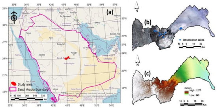
It might be difficult to find possible groundwater reservoir zones, especially in arid or hilly regions. In the twenty-first century, remotely sensed satellite imagery may present a new opportunity to locate surface and subsurface water resources more quickly and affordably. In order to identify groundwater potential zones, the current study was conducted in Central Saudi Arabia, southwest of Riyadh. The present analysis employed a multi-criteria approach that relies on remote sensing and geographic information systems. The variables employed in this technique include geology, rainfall, elevation, slope, aspect, hillshade, drainage density, lineaments density, and Land Use/Land Cover (LULC). The Analytical Hierarchical Process (AHP) was used for assigning weights to the parameters, and the corresponding significance of each parameter’s several classes for groundwater potentiality. Different groundwater potential zones were identified by the study: very high (16.8%), high (30%), medium (26.7%), low (18.6%), and very low (7.9%). Only two of the observation wells were located in the “medium” potential zone, but the other ten wells were observed in the “very high and high” potential zones, according to the validation survey. Consequently, the results may demonstrate that the current approach, which combines improved conceptualization with AHP to define and map groundwater potential zones, has a greater chance of producing accurate results and can be used to reduce the threat of drought in broader arid regions.
Hydrology, Vol. 11, Pages 38: An Integrated Remote Sensing and GIS-Based Technique for Mapping Groundwater Recharge Zones: A Case Study of SW Riyadh, Central Saudi Arabia
Hydrology doi: 10.3390/hydrology11030038
Authors: Eman Mohamed M. EL-Bana Haya M. Alogayell Mariam Hassan Sheta Mohamed Abdelfattah
It might be difficult to find possible groundwater reservoir zones, especially in arid or hilly regions. In the twenty-first century, remotely sensed satellite imagery may present a new opportunity to locate surface and subsurface water resources more quickly and affordably. In order to identify groundwater potential zones, the current study was conducted in Central Saudi Arabia, southwest of Riyadh. The present analysis employed a multi-criteria approach that relies on remote sensing and geographic information systems. The variables employed in this technique include geology, rainfall, elevation, slope, aspect, hillshade, drainage density, lineaments density, and Land Use/Land Cover (LULC). The Analytical Hierarchical Process (AHP) was used for assigning weights to the parameters, and the corresponding significance of each parameter’s several classes for groundwater potentiality. Different groundwater potential zones were identified by the study: very high (16.8%), high (30%), medium (26.7%), low (18.6%), and very low (7.9%). Only two of the observation wells were located in the “medium” potential zone, but the other ten wells were observed in the “very high and high” potential zones, according to the validation survey. Consequently, the results may demonstrate that the current approach, which combines improved conceptualization with AHP to define and map groundwater potential zones, has a greater chance of producing accurate results and can be used to reduce the threat of drought in broader arid regions.
What's Your Reaction?