












Hydrology, Vol. 11, Pages 28: Sensitivity of Groundwater Recharge Assessment to Input Data in Arid Areas
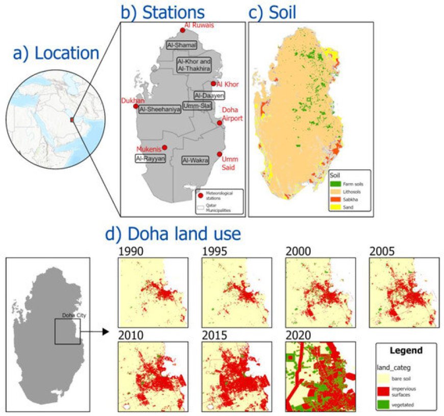
Natural groundwater recharge (GR) assessment depends on several hydrogeological and climatic inputs, where uncertainty is inevitable. Assessing how inputs’ uncertainty affects GR estimation is important; however, it remains unclear in arid areas. This study assesses inputs’ uncertainty by examining the changes in GR simulations resulting from modifications in climatic, land use, and soil inputs. A physical-based hydrological model was built to estimate GR from 18 different GR scenarios across Qatar. Scenarios S1–S7 were created from different climatic inputs but identical land use and soil maps. Scenarios S8–S14 were created from different land use maps (analyzed from historical Landsat satellite images) but similar climatic and soil inputs. In S15–S18, the soil parameters were changed while the climatic and land use maps were kept the same. The results show that climatic inputs are key factors controlling the GR in arid areas, followed by land use inputs and soil classification. A strong correlation was observed between the GR values and precipitation, while moderate (non-significant) correlations were observed between the GR values and potential evapotranspiration and wind speed. Soil changes affected the GR simulations but inconsiderably compared with climatic and land use inputs. Since GR estimation is fundamental but uncertain in arid areas, the study findings contribute to narrowing the uncertainty in GR estimation.
Hydrology, Vol. 11, Pages 28: Sensitivity of Groundwater Recharge Assessment to Input Data in Arid Areas
Hydrology doi: 10.3390/hydrology11020028
Authors: Salah Basem Ajjur Emanuele Di Lorenzo
Natural groundwater recharge (GR) assessment depends on several hydrogeological and climatic inputs, where uncertainty is inevitable. Assessing how inputs’ uncertainty affects GR estimation is important; however, it remains unclear in arid areas. This study assesses inputs’ uncertainty by examining the changes in GR simulations resulting from modifications in climatic, land use, and soil inputs. A physical-based hydrological model was built to estimate GR from 18 different GR scenarios across Qatar. Scenarios S1–S7 were created from different climatic inputs but identical land use and soil maps. Scenarios S8–S14 were created from different land use maps (analyzed from historical Landsat satellite images) but similar climatic and soil inputs. In S15–S18, the soil parameters were changed while the climatic and land use maps were kept the same. The results show that climatic inputs are key factors controlling the GR in arid areas, followed by land use inputs and soil classification. A strong correlation was observed between the GR values and precipitation, while moderate (non-significant) correlations were observed between the GR values and potential evapotranspiration and wind speed. Soil changes affected the GR simulations but inconsiderably compared with climatic and land use inputs. Since GR estimation is fundamental but uncertain in arid areas, the study findings contribute to narrowing the uncertainty in GR estimation.
What's Your Reaction?