











Hydrology, Vol. 10, Pages 228: Coastal Inundation Hazard Assessment in Australian Tropical Cyclone Prone Regions
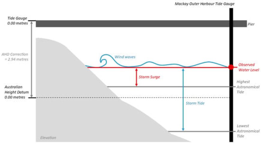
One of the hazards associated with tropical cyclones (TCs) is a storm surge, which leads to coastal inundation and often results in loss of life and damage to infrastructure. In this study, we used GIS-based bathtub models and tide-gauge-derived water levels to assess coastal inundation scenarios for the landfall region of TC Debbie. The three scenarios modelled what could have happened if the TC’s maximum storm surge had coincided with the maximum storm tide for that day, month, or TC season, where the water levels were determined through analysis of tide gauge data, using a new method called the variable enhanced Bathtub Model. Additionally, this study analysed the impact of excluding the correction of water levels with the Australian Height Datum. Our study found that between the least and most severe scenarios, with the input water-level difference for the model along the coastline being 0.43 m, the observed inundation depth of the analysed populated region increased from 0.25 m to 1 m. Ultimately, it was found that in the worst-case scenario, the study region could have experienced coastal inundation 0.63 m higher than it did, inundating 72.53 km2 of the coast. The results of this study support the consensus that coastal inundation is highly dependent on the characteristics of the terrain, and that coastal inundation modelling, such as that completed in this study, needs to be performed to better inform decision makers and communities of the potential impacts of TC-induced storm surges.
Hydrology, Vol. 10, Pages 228: Coastal Inundation Hazard Assessment in Australian Tropical Cyclone Prone Regions
Hydrology doi: 10.3390/hydrology10120228
Authors: Jane Nguyen Yuriy Kuleshov
One of the hazards associated with tropical cyclones (TCs) is a storm surge, which leads to coastal inundation and often results in loss of life and damage to infrastructure. In this study, we used GIS-based bathtub models and tide-gauge-derived water levels to assess coastal inundation scenarios for the landfall region of TC Debbie. The three scenarios modelled what could have happened if the TC’s maximum storm surge had coincided with the maximum storm tide for that day, month, or TC season, where the water levels were determined through analysis of tide gauge data, using a new method called the variable enhanced Bathtub Model. Additionally, this study analysed the impact of excluding the correction of water levels with the Australian Height Datum. Our study found that between the least and most severe scenarios, with the input water-level difference for the model along the coastline being 0.43 m, the observed inundation depth of the analysed populated region increased from 0.25 m to 1 m. Ultimately, it was found that in the worst-case scenario, the study region could have experienced coastal inundation 0.63 m higher than it did, inundating 72.53 km2 of the coast. The results of this study support the consensus that coastal inundation is highly dependent on the characteristics of the terrain, and that coastal inundation modelling, such as that completed in this study, needs to be performed to better inform decision makers and communities of the potential impacts of TC-induced storm surges.
What's Your Reaction?